The shape of clouds
Cumulus clouds ("fair weather clouds") form under the influence of thermals – convection currents which channel moist air upwards. As the temperature of the air drops with altitude, water vapor condenses into droplets; the cloud is the collection of these droplets.
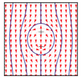
Figure 1: Flow field around a plume, in the frame of reference of the ascending plume.
The question that interests us is what aspects of the cloud can be understood simply in terms of the coherent structures in the flow field. This is a question one can ask of many turbulent systems, and the answer in this case is the shape of the cloud. The coherent structures in question are thermal plumes, and we use a simple description of the flow field of the plume introduced years ago by Moses et al [1]. We build a model where a collection of such plumes pushes around the droplets in the cloud.
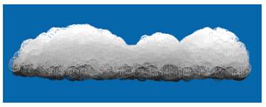
Figure 2: A collection of the objects on the left interacting with an initially uniform collection of droplets produces the characteristic shape of cumulus clouds.
This dynamics results in the characteristic "cauliflower" shape of the top of cumulus clouds, and accounts quantitatively for statistical shape descriptors such as the measured fractal dimension of clouds. The model is computationally of minimal complexity, so it represents a simple quantitative description of a complex everyday phenomenon.
Associated publications:
- Y. Wang and G. Zocchi, "The shape of fair weather clouds", Phys. Rev. Lett. 104, 118502 (2010).
- E. Moses, G. Zocchi, I. Procaccia and A. Libchaber, "The dynamics and interactions of laminar thermal plumes", Europhys. Lett. 14, 55 (1991).